
A lot has changed since our morning weather update on the impacts of Hurricane Ian as the storm makes its way toward South Carolina and North Carolina.
As of 2 p.m., Ian was still a Tropical Storm, but back out in the open waters of the Atlantic Ocean and starting to gain strength again, after leaving a nasty mark on Florida.
The trip into the Atlantic is giving Ian a chance to rebuild a bit, and current projections have it getting back up to hurricane strength, before making landfall somewhere between Charleston and Myrtle Beach in South Carolina.
The latest model runs have that trending northward, which also has direct impacts on us here in the Sandhills. More on that below.
Also of note, in the last few hours, most of the school systems in the region have made Friday a remote day. You can see all the closings and adjustments on our special page here.
As we said earlier, Gov. Cooper has already declared a State of Emergency, so resources could be freed up easier.
“A State of Emergency is needed now so that farmers and those preparing for the storm can more quickly get ready for the heavy rain that is likely to fall in much of our state,” said Governor Cooper. “North Carolinians should stay aware, keep a close eye on the forecast and prepare their emergency supplies.”
In addition, North Carolina’s price gouging law against overcharging in a state of emergency is now in effect statewide.
Here’s a look at what’s going on with Tropical Storm Ian as of 2:15 Thursday afternoon, and his upcoming impact on North Carolina. Keep coming back to this page, as we will update it regularly, before posting a new story Friday morning.
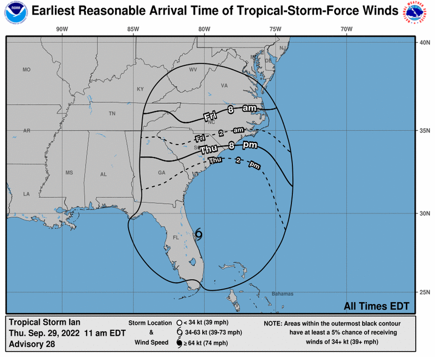
Arrival Times
The speeding up of Ian has made for arrival times of tropical storm force winds earlier as well. Expect more of those late tonight, into the morning. The storm should make landfall again by Friday afternoon, but impacts will be felt long before that.
Rainfall Expectations
Heavy rainfall is expected, with upwards of 5 inches in some of our listening area. Flash flooding threats have increased substantially for Friday, instead of Saturday.

Fayetteville Impacts
Even with a landfall in South Carolina, the large rain field for this storm WILL bring impacts to Southeastern North Carolina. This model shows heavy rain throughout South Carolina and North Carolina.

Wind Field Projections
