Severe Weather Watch: Tracking Hurricane Ian

Severe Weather Watch: Tracking Hurricane Ian

Severe Weather Watch: Tracking Hurricane Ian

Image Courtesy National Weather Service.

Hurricane Ian became Tropical Storm Ian overnight, as he worked his way slowly up the heart of Florida, on his way toward the Atlantic Ocean, with eyes on South Carolina and North Carolina.

Coastal areas in North Carolina and South Carolina are now under Tropical Storm Warning at minimum, and North Carolina Gov. Roy Cooper has issued a State of Emergency for the state.

“A State of Emergency is needed now so that farmers and those preparing for the storm can more quickly get ready for the heavy rain that is likely to fall in much of our state,” said Governor Cooper. “North Carolinians should stay aware, keep a close eye on the forecast and prepare their emergency supplies.”

The order waives the size and weight requirements for vehicles engaged in relief efforts before, during and after the severe weather, including power restoration and debris removal, as well as the transportation of goods like food, fuel, and medical supplies. The order also helps North Carolina’s agricultural sector by temporarily suspending weighing of vehicles used to transport livestock, poultry or crops ready to be harvested. The Council of State concurred with the waiver of transportation regulations in the order today.

In addition, North Carolina’s price gouging law against overcharging in a state of emergency is now in effect statewide.

Here’s a look at what’s going on with Tropical Storm Ian as of 8:30 Thursday morning, and his upcoming impact on North Carolina. Check back all day, as we’ll keep you posted.

  • 11 a.m. UPDATE: Tropical Storm Warning

    As of 11 a.m. Thursday, nearly all of Southeastern and Central North Carolina is now under a Tropical Storm Warning.

    A Tropical Storm Warning means tropical storm-force winds are expected somewhere within this area within the next 36 hours

    – A Tropical Storm Warning has been issued for Alamance, Anson,
    Chatham, Cumberland, Davidson, Durham, Edgecombe, Forsyth,
    Franklin, Guilford, Harnett, Hoke, Johnston, Lee, Montgomery,
    Moore, Nash, Orange, Randolph, Richmond, Sampson, Scotland,
    Stanly, Wake, Wayne, and Wilson

  • Overall Projection

  • Storm Timeline

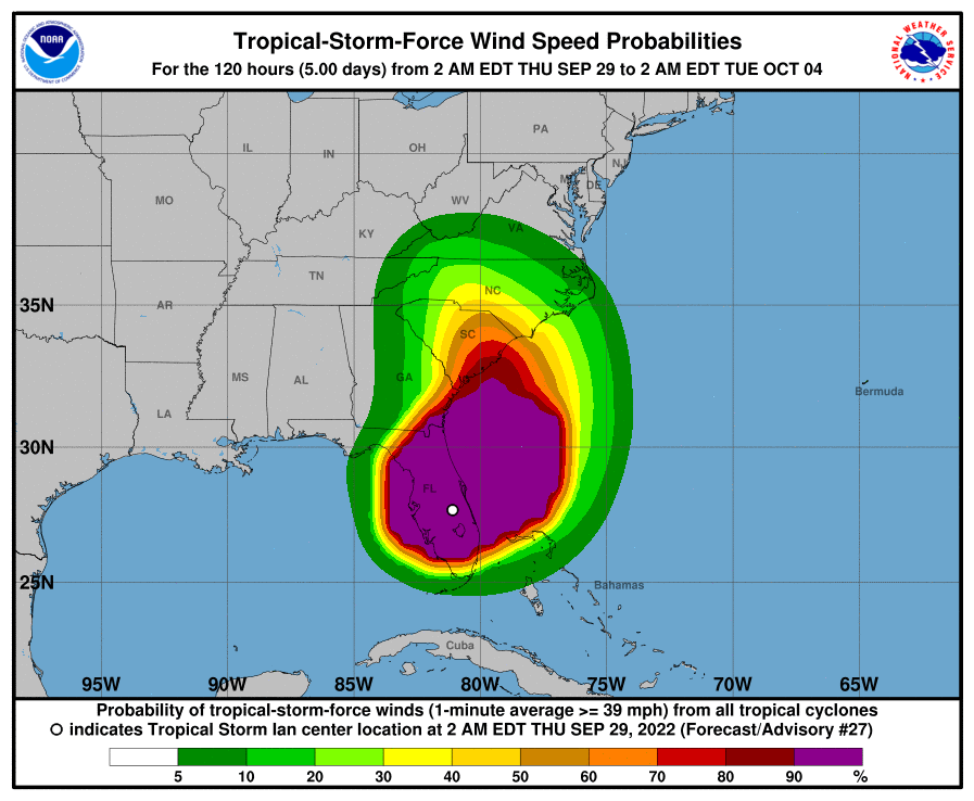
    The biggest takeaway from overnight developments is that Ian has shifted slightly East, which will bring additional wind and rain threats into the Carolinas.

  • Rainfall

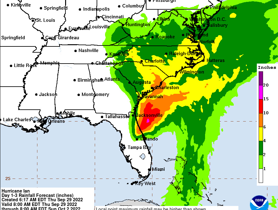
    Heavy rainfall is expected, with upwards of 5 inches in some of our listening area. Flash flooding threats have increased substantially for Friday, instead of Saturday.

  • Landfall Expectation

    Currently, models project that Ian will head back into the Atlantic and strengthen again a little bit. It’s unclear if Ian will be able to get back to Hurricane strength before an expected landfall somewhere along the center of South Carolina, likely near Charleston.

  • Fayetteville Impacts

    Even with a landfall in the Charleston area, the large rain field for this storm WILL bring impacts to Southeastern North Carolina. This model shows heavy rain throughout South Carolina and North Carolina.

  • Rain in Florida

    Heartbreaking images are coming from throughout Central Florida, with up to 17 inches of rain in some areas. We’ll have a gallery later.

  • Rain Forecast

    As you can see from the National Weather Service projection, rain will impact much of South Carolina and North Carolina, between tonight and Sunday.

    hurricane tropical storm Ian North Carolina rain

    Image Courtesy National Weather Service.

  • Wind Field Projections

    hurricane tropical storm Ian North Carolina rain wind

    Image Courtesy National Weather Service.

  • NWS Raleigh Projection

Sign me up for the Foxy 99 email newsletter!

Join the Foxy Family and you'll get the hottest hip-hop news and notes, as well as the best concerts, contests, and ways to get cash in your pocket!

*
*
By clicking "Subscribe" I agree to the website's terms of Service and Privacy Policy. I understand I can unsubscribe at any time.